
When a task force set out to draw lines for the new supervisorial districts in 2002, a lot of us were worried. Willie Brown was mayor, and he would have significant influence on the task force. Bad lines could divide up communities, fracture alliances—and, like any gerrymandering, elect people who don’t represent the most vulnerable communities in the city.
But it was fine. The lines were pretty much what the city had put in place when the voters restored district elections. The task force tinkered around the edges to adjust for population, but nobody was unhappy.
Ten years later, we worried again. Gavin Newsom was mayor; just a little bit of political influence could have made it harder to elect progressives. Again: It was fine.
As Sup. Aaron Peskin told me recently, since the return of district elections everyone has played by the book. They’ve kept the politics out of it, kept neighborhoods together, and made changes only around the margins.
Not this time.
The most recent district lines, which a sharply divided task force seems prepared to accept, would take the most progressive district in the city, which has elected two Green Party members and a Democratic Socialist, and blow it to bits.
It’s strange: District 5 has had very little population change, but the vast majority of the redistricting changes have happened there. “It’s makes me suspicious and I start to distrust the process,” Christin Evans, who owns a bookstore in the Haight and is part of the Haight Ashbury Merchants Association, told me.
The task force—by a 5-4 vote—decided March 25 to continue its work with a map known as 3B as a starting point. Another version, 3A, is pretty close to the current lines and doesn’t make any radical changes.

But 3B does.
Now, another new version, 4A, goes even further.
Take a look at the map here:
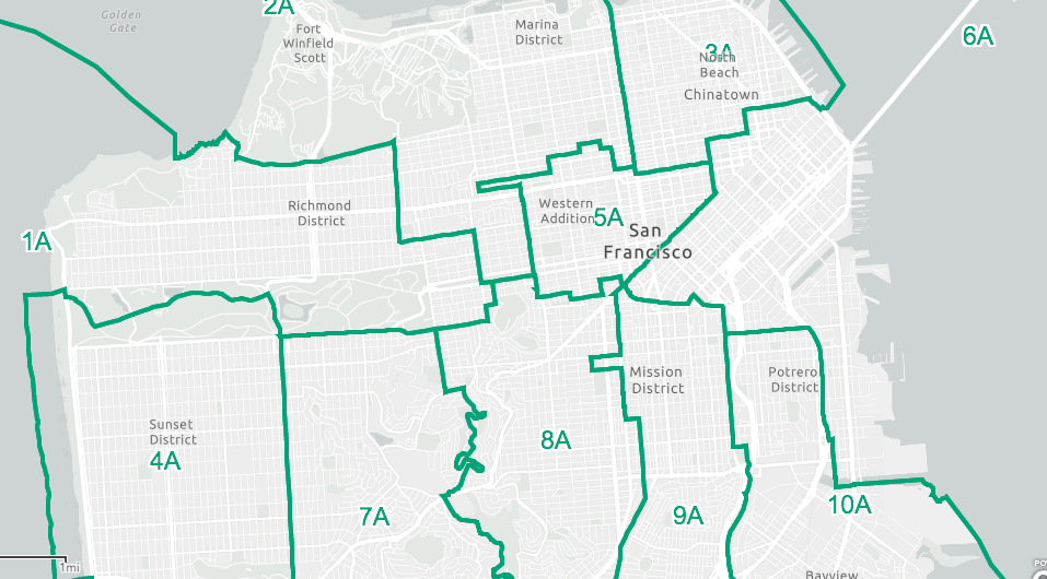
Since the first version of district elections, in 1977, the Haight Ashbury neighborhood has been in intact part of a district. Version 3B would split the Haight and the Western Addition, moving most of the Haight into district 1 or district 7, and moving the Tenderloin from D6 into D5.
Map 4A would shift part of the Western Addition into District 2, the most conservative district in the city.
Meanwhile, D6 would be made up largely of residents in the new condo buildings that we’ve seen in the past decade, meaning it’s going to be a much more conservative district.
So the progressives lose that one (or, if Matt Haney isn’t elected to state Assembly, get a representative who is moving hard to the Yimby side). District 4 moves west, meaning it will be almost impossible for a candidate like Gordon Mar to win. The progressive vote in D5 is scattered. D3 picks up more conservative areas on the edge of the Marina.
“This is,” Calvin Welch, a longtime neighborhood activist, told me, “a clear and direct attack on the progressive board majority.”
There are three meetings next week, April 2, 4, and 6. And there will no doubt be more versions.
But this process keeps coming up with maps that stray further and further from the old districts, for no apparent demographic reason.
I once said that it would be hard to draw 11 bad districts in San Francisco. I was wrong; the task force has done it.
You think the Mayor’s Office might be behind all of this?